 |
 |
 |
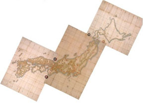
Inoh Tadataka's map of Japan, 1821
|
 |
If you're a map freak, as I am, and you are in the Tokyo area, then a trip out to Sawara is mandatory. It's especially convenient for travelers with a few hours to kill between flights at Narita International Airport, because Sawara is just a half hour by local train from Narita station.
Sawara is famous for its old quarter of lovingly preserved Edo-era townhouses along the banks of the willow-lined Ono River, which earns the town its nickname "Little Edo." Due to its strategic location where the Ono meets the mighty Tone, Japan's greatest waterway, Sawara was a thriving merchant town that benefited by being a bit of a remove from the political center of Edo. Sawara's citizens enjoyed more intellectual freedom than their big-city counterparts, it seems, and felt free to indulge, for example, an interest in Western science.
 |
 |
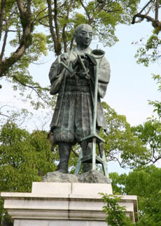
Inoh Tadataka (1745-1818),
in surveyor garb
|
Inoh Tadataka (1745-1818), a wealthy Sawara rice and sake merchant, had ancestors with a penchant for surveying and mapmaking, and perhaps thus influenced he developed a fascination with astronomy in middle age. Retiring from his business at 49, he moved to Edo, where he studied for five years with the Shogunate's official astronomer, then set out on the first of ten surveying expeditions the length and breadth of Japan. That initial effort, to make the first accurate map of the northern island of Ezo (now Hokkaido), so impressed the Shogunate that it commissioned him for several more expeditions. Inoh traveled and surveyed almost incessantly for 17 years until shortly before his death; his masterwork, a detailed map of the entire Japanese archipelago, was published posthumously in 1821. The soon-to-be legendary "Inoh Map" (Inoh-zu) was so accurate that it set the standard for maps of Japan, both domestic and foreign, for another century -- German and British cartographers copied it too.
The Inoh Tadataka Museum is Sawara's spacious, well-organized tribute to this remarkable favorite son. Fortunately for visitors in transit from Narita, it offers reasonably detailed English descriptions of its exhibits, most of which are, naturally, maps, of all sizes and scales. One of the most revealing is an electronic display that superimposes the Inoh Map on a recent Landsat photo of Japan. Aside from some slight longitudinal deviation (longitude, which Inoh tried to derive from observations of solar and lunar eclipses, was much harder to measure than latitude), the Inoh Map is an astonishingly close match to the satellite's.
Nearly as fascinating as Inoh's maps are the museum's charts of the labyrinthine routes he took on his expeditions, zigzagging his way up and down the archipelago with a band of surveyors, retainers and guards. (It is interesting to see how Inoh's mapping accuracy improved as the Shogun increased his budgetary support.)
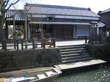
A stroll across the picturesque Ono takes you to Inoh's ancestral homestead, which, though restored in recent years, still looks a bit dilapidated but all the more authentic for it. Indeed, the entire old quarter of Sawara is a stroller's delight; even if you're not terribly interested in maps, the Inoh Museum and residence provide an excellent pretext for exploring the town.
|
|
 |
Boating along the Ono River
in old Sawara
|
|
Inoh's residence, across the Ono
from the museum
|
|